Hubdate #2 – Real-Time Data and UPRNs
The Digital Solutions Hub (DSH), a free online mapping toolkit funded by the Natural Environment Research Council (NERC), will make over 40 petabytes of environmental data searchable and ready to do analysis on. On top of the 40+ petabytes of environmental data from NERC, and a wealth of data from other sources such as the Office for National Statistics, the Digital Solutions Hub will host a variety of real-time data that will be available down to the local neighbourhood scale due to the integrated UPRN service.
UPRNs, or Unique Property Reference Numbers, are individual identifiers for civil, domestic and commercial buildings that allow data to be pinpointed down to a neighbourhood scale. It is essentially an X/Y coordinate for the central location of a building. The combination of real-time data with UPRNs in the Digital Solutions Hub will transform decision-making through the understanding of local environmental changes and pressures on communities.
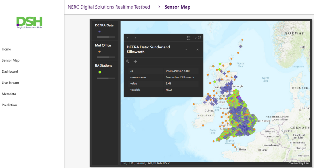
The Hub, which will draw on data from external (but integrated) and trusted sources such as the UK Health Security Agency and the Environment Agency, will allow the visualisation and analysis of real-time data. Examples of these data sets include, but are not limited to, traffic congestion, air and noise pollution levels, and chemical, radiological and nuclear threats.
Whilst also useful for informing long-term planning decisions, this real-time data will also be useful for short-term planning. For example, live data on air pollution will allow NHS trusts to better prepare for an influx of patients arriving to A&E from known triggers like high air pollution levels. By using the Hub to track real-time data in the local area and ensure that staffing levels reflect predicted increases in patients, trusts will be able to become more resilient to shocks and triggers.
Another example use of real-time data and UPRNs is understanding extreme weather events on transport infrastructure such as the overtopping of sea walls with consequent impacts on the railway network as we have seen in Dawlish in Devon. Being able to predict such disruptions can help a range of organisations plan ahead and develop emergency plans and mitigate or adapt to our changing environment.
Are you interested to try the Hub when it is launched? Sign up to our mailing list to be on our early-access list.
If you have any questions about the NERC Digital Solutions Hub, how it works, or maybe you have queries about how UPRNs and real-time data will work? Please do get in touch, we would be delighted to answer your questions.